The Enclave — Detached Collection

Southeast Milton

Location — Britannia Road & James Snow Parkway, Milton

New detached homes at Britannia Road, Milton

The Enclave sits at the northwest corner of Britannia Road and James Snow Parkway in southeast Milton, Ontario, near the Milton GO Station on the Kitchener line and with direct access to Highway 401. The surrounding area includes Mohawk Park, the Niagara Escarpment trail network, and downtown Milton's Dundas Street retail corridor.

Prices, sizes, specifications, and availability are subject to change without notice. E.&O.E. Information current as of October 2026.

The municipal address is 6071 Fourth Line. The Town of Milton locates the site at the northwest corner of Britannia Road and James Snow Parkway, in southeast Milton. Sundial Homes markets The Enclave on Britannia Road between James Snow Parkway and Fourth Line. Those descriptions point at the same masterplan, not at two different communities.

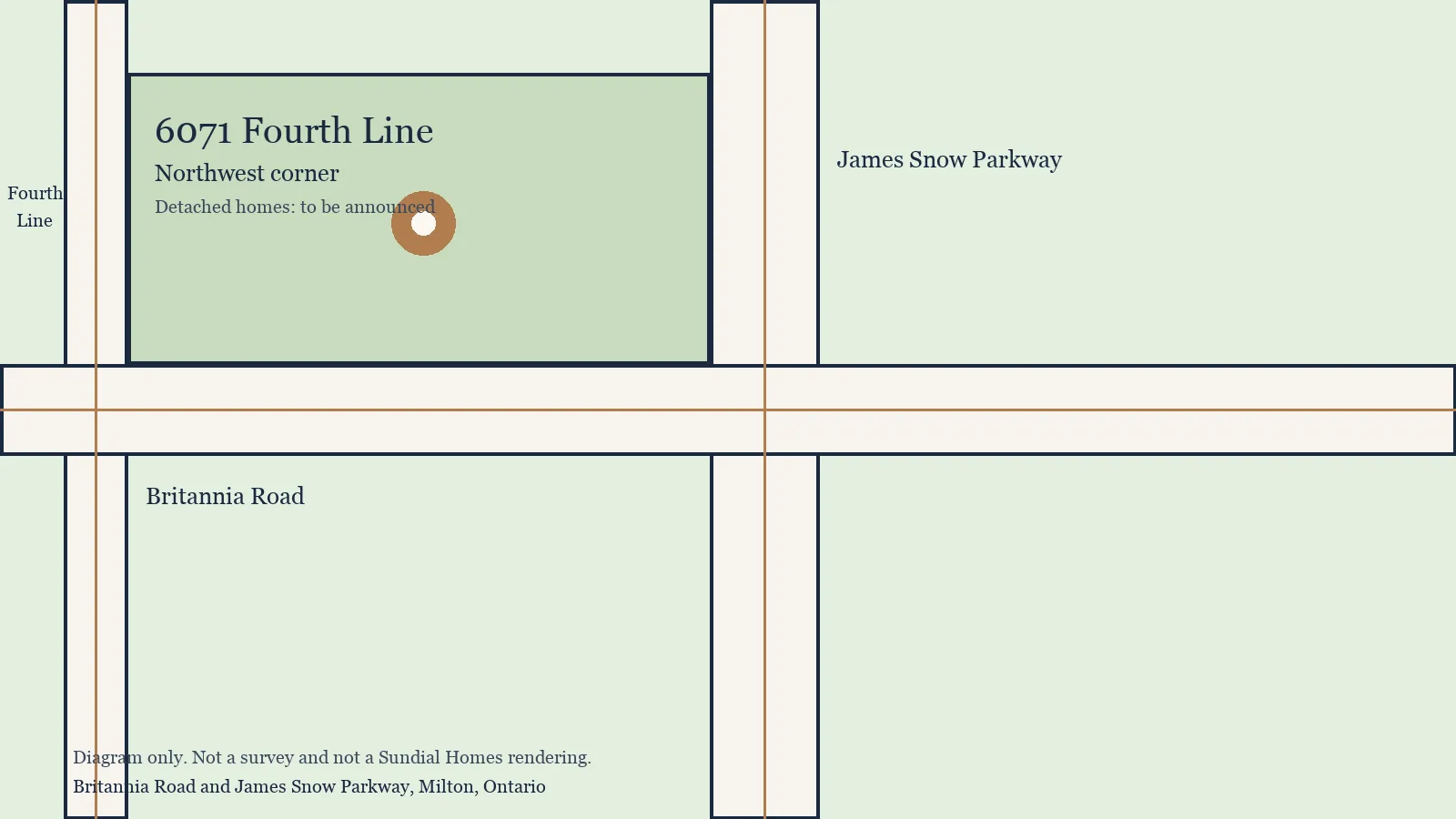
Fourth Line and James Snow Parkway both run north-south in this part of Milton. Britannia Road runs east-west. The northwest corner of Britannia and James Snow is the planning location. A diagram on this page shows that relationship. It is not a survey, and it is not a lot plan.

An exact walking time to Milton GO Station, and the nearest Highway 401 interchange measured from a future driveway, are still to be confirmed. Both are left blank on purpose. The station and the highway are real. A made-up minute count is not.

Diagram of new detached homes at Britannia Road in Milton, marking the northwest corner of Britannia Road and James Snow Parkway as 6071 Fourth Line. Not a survey.

Transit

Transit near The Enclave in Milton
FieldDetail
StationMilton GO Station
LineKitchener line to Toronto Union Station
Distance from 6071 Fourth LineTo be confirmed — exact driving and walking distance depends on the final site plan

Highway access

Highway access near Britannia Road in Milton
FieldDetail
CorridorHighway 401
Nearest interchangeTo be confirmed — the nearest interchange has not been measured from the final site plan

Schools near The Enclave in Milton

Schools near The Enclave in Milton
LevelSchoolBoard
ElementaryViola Desmond Public SchoolHalton District School Board
ElementaryEthel Gardiner Public SchoolHalton District School Board
ElementaryHawthorne Village Public SchoolHalton District School Board
SecondaryCraig Kielburger Secondary SchoolHalton District School Board
SecondaryMilton District High SchoolHalton District School Board
Catholic SecondaryBishop Reding Catholic Secondary SchoolHalton Catholic District School Board
Catholic SecondarySt. Benedict Catholic Secondary SchoolHalton Catholic District School Board

School catchments are determined by exact address and can change. Confirm current boundaries with the relevant school board before relying on this list.

Milton, Halton, and this intersection

Milton is a town in Halton Region, Ontario. Halton Region also includes Burlington, Oakville, and Halton Hills. The Enclave site is in southeast Milton, at 6071 Fourth Line, on the northwest corner of Britannia Road and James Snow Parkway. That intersection is the planning location in Town file 24T-21006/M.

Commuter rail from this part of Milton uses Milton GO Station on GO Transit's Kitchener line, with service to Toronto Union Station. Highway 401 is the east-west freeway for the south end of Milton. Both are real pieces of regional infrastructure. The walking distance from a future front door at 6071 Fourth Line to the GO platform, and the nearest 401 interchange measured from that driveway, are still to be confirmed against the final site plan.

The Niagara Escarpment crosses the north of Milton and carries a public trail network. Southeast Milton is not the escarpment brow. The escarpment is listed as a nearby landmark because Sundial Homes' Enclave marketing names it, not because this page has measured a trailhead.

Everyday retail in Milton concentrates along Dundas Street. Downtown Milton is the older centre of the town, separate from the Britannia Road growth area. Mohawk Park is another named landmark. None of those places is given a drive time here.

Hospitals people ask about from this address are Milton District Hospital, Oakville-Trafalgar Memorial Hospital, and Credit Valley Hospital. They are named without a kilometre figure. A third-party distance is easy to copy and easy to get wrong once the internal road network of the masterplan is built. Confirm a route when the street access is final.

Schools named as nearby are Viola Desmond Public School, Ethel Gardiner Public School, and Hawthorne Village Public School for Halton District elementary; Craig Kielburger Secondary School and Milton District High School for Halton District secondary; and Bishop Reding Catholic Secondary School and St. Benedict Catholic Secondary School for Halton Catholic secondary. The Town filing also includes a public elementary school site inside the masterplan, subject to school board approval. A site on a plan is not an open school.
Retail, parks, and landmarks

Mohawk Park

Mohawk Park is a public park in Milton that sits among the landmarks buyers ask about when they look at southeast Milton. Sundial Homes' Enclave marketing names it as a nearby landmark.

This page does not state a distance from 6071 Fourth Line to Mohawk Park. That measurement is not in the Town filing, and a guessed minute-count would be less useful than none.

Niagara Escarpment trail network

The Niagara Escarpment is the long limestone ridge that shapes north Milton and the wider Halton landscape, with a public trail network along it. Southeast Milton is in the same town, not on the escarpment brow.

The Enclave's marketed location is southeast Milton, with the escarpment trail network listed as a nearby landmark. No trailhead distance is published here.

Downtown Milton

Downtown Milton is the older centre of the town, separate from the Britannia Road and James Snow Parkway growth area. It is named as a nearby landmark in the Enclave marketing.

A drive time from 6071 Fourth Line to downtown is not stated on this page. Use a map for a current route rather than a rounded claim.

Dundas Street retail corridor

Dundas Street is Milton's main east-west retail street, with grocery, everyday services, and larger shops. Enclave marketing identifies the Dundas Street retail corridor as a nearby landmark.

Which plaza is closest to the site, and how long the drive takes, depends on the final street access. Those details are not confirmed here.

Hospitals

Distances from 6071 Fourth Line to Milton District Hospital, Oakville-Trafalgar Memorial Hospital, and Credit Valley Hospital are not confirmed against the final site plan. Earlier third-party listings have quoted hospital distances for this address. Those figures are not repeated here. Confirm a current route before relying on any travel time.

  • Milton District Hospital
  • Oakville-Trafalgar Memorial Hospital
  • Credit Valley Hospital

Nearby Milton pre-construction context

Buyers comparing The Enclave in Milton with other pre-construction communities can look at two projects whose own websites were live in October 2026. Elements Milton is a townhome community at Bronte Street South and Britannia Road. The Valleylands of Sixteen Mile Creek is a Fieldgate Homes detached community at 8625 Britannia Road. Names and locations only are given here. Detached pricing at The Enclave has not been released, so this page does not compare prices, deposits, or incentives.

Elements Milton

Townhomes

Bronte Street South and Britannia Road, Milton

Confirmed on theelementsmilton.ca in October 2026. No price is quoted here.

Register for detached collection updates

Detached homes are releasing soon at Britannia Road and James Snow Parkway. Pricing and a launch date are coming soon. Register to be told when Sundial Homes publishes them.

By registering, you agree to receive updates about Detached Homes. You can unsubscribe at any time.

Register for Detached Collection Updates